
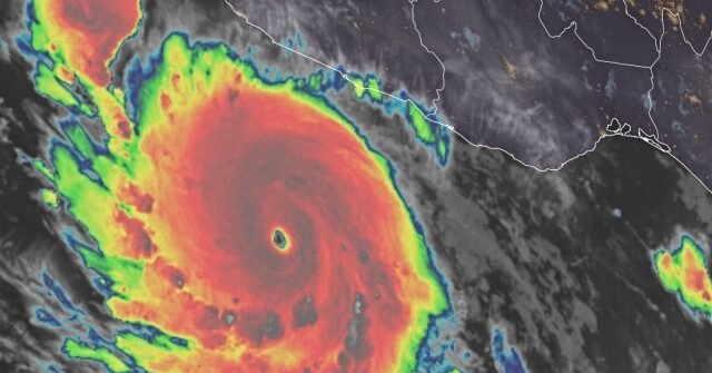
Hurricane Polo shot from a newly designated hurricane to a Category 5 storm in less than 24 hours, intensifying early Tuesday over the eastern Pacific off Mexico’s southwest coast, according to the National Hurricane Center.
The storm’s rapid escalation comes amid an unusually busy stretch of Pacific activity tied to El Niño, which has helped generate 18 storms in the Pacific Basin, Fox Weather reported. The National Hurricane Center is tracking several areas across the region at once.
Where the storm stands
As of the latest advisory, Polo was a Category 5 hurricane centered roughly 220 miles southwest of cities along Mexico’s southwest coast. The storm was moving east at 6 mph with maximum sustained winds of 160 mph, according to the NHC.
NBC News reported that Polo was centered about 360 miles south-southeast of Manzanillo. Authorities issued a tropical storm watch covering part of the coastline from south of Manzanillo in Colima state to Tecpan de Galeana in Guerrero state, signaling that tropical storm conditions could arrive within two days.
Forecasters do not expect Polo to come ashore near the United States. Officials predict the hurricane will make a sharp turn to the northwest and then west-northwest, skirting Mexico’s coast while lingering nearby for several days, according to NBC News. Even so, the system is expected to bring heavy rain and the potential for flooding and landslides to Guerrero and Michoacán states over the coming days.
Radar imagery showed the storm churning over open ocean close to the Mexican coast, its circulation staying offshore while still threatening nearby communities with rain and rough conditions.
Moisture reaches the U.S. Southwest
Polo’s influence is not confined to Mexico. Moisture streaming north from the hurricane is already flowing into the southwestern United States and is expected to boost monsoon thunderstorms over New Mexico starting Tuesday, officials said — a pattern in which tropical systems hundreds of miles away can amplify summertime storm activity far inland.
The Category 5 designation reflects the storm’s wind strength rather than its location. According to the National Oceanic and Atmospheric Administration, a storm becomes a hurricane once its maximum sustained winds reach 74 mph, and the higher the category, the greater the risk of damage should the storm reach land. Polo’s 160 mph winds put it at the top of that scale.
NOAA notes that hurricanes form in the Atlantic basin — including the Atlantic Ocean, Caribbean Sea and Gulf of America — as well as the eastern North Pacific Ocean and, less frequently, the central North Pacific. Polo’s development and rapid intensification fall within that eastern Pacific zone, where El Niño conditions have helped fuel an active stretch of storm formation this season.
What comes next
Forecasters are watching for the sharp turn that should keep Polo offshore, but they caution that a storm lingering near the coast for days can still deliver prolonged rainfall and dangerous conditions on land. The tropical storm watch along the Colima and Guerrero coastline remains the primary official warning for Mexico, while communities in New Mexico and the wider Southwest could see enhanced monsoon thunderstorms from Polo’s moisture beginning Tuesday.
With 18 storms already recorded in the Pacific Basin this season and the hurricane center monitoring multiple systems, Polo’s rapid climb to Category 5 status adds another significant system to an already crowded map — one that, while staying out to sea, is still shaping weather on both sides of the border.
Source: www.breitbart.com — https://www.breitbart.com/weather/2026/09/22/video-polo-becomes-category-5-hurricane-in-under-24-hours/